
The north of england доклад
Обновлено: 02.07.2024
England is the largest and the richest country of Great Britain. The capital of England is London but there are other large industrial cities, such as Birmingham, Liverpool, Manchester and other famous and interesting cities such as York, Chester, Oxford and Cambridge. Stonehenge is one of the most famous prehistoric places in the world. This ancient circle of stones stands in Southwest England. It measures 80 metres across and made with massive blocks of stone up to four metres high. Why it was built is a mystery.
Not far from Stonehenge stands Salisbury Cathedral. It is a splendid example of an English Gothic Cathedral; inside there is one of four copies of Magna Charta and the oldest clock in England. Chester is very important town in the north-west of England. In the past it used to be a Roman fort; its name comes from the Latin word castra, meaning "fortified camp". In Chester there is a famous museum which contains over 5000 ancient and modern toys.
Oxford is the home of the oldest university of England. The most famous college is Christ Church. It has a great hall which was built during the reign of Henry VIII and its chapel has become the Cathedral of Oxford. Cambridge is the home of Britain's second oldest university. York was the capital of Northern England. It is one of the best preserved medieval cities of Europe. It was built by Romans, conquered by Anglo-Saxons and ruled by the Vikings. Birmingham is often called the "City of 1,500 trades" because of the great variety of its industries.
Англия - самая большая и самая богатая страна Великобритании. Столица Англии - Лондон; но существуют и другие важные города, например Бирмингем, Ливерпуль и Манчестер и другие известные и интересные города, такие как Йорк, Честер, Оксфорд и Кембридж. Стоунхендж - одно из самых известных доисторических мест в мире. Это древний круг из камней, находящийся на юго-востоке Англии. Его диаметр равняется 30 метрам, и сделан он из массивных каменных блоков до четырех метров высотой. Почему он был построен - загадка.
Недалеко от Стоунхенджа стоит Солсберийский собор. Это прекрасный пример английского готического собора; внутри него хранится одна из четырех копий Великой Хартии и самые старые часы Англии. Честер - очень важный город на северо-западе Англии. В прошлом это был римский форт; название его происходит от латинского слова "castra", что означает "укрепленный лагерь". В Честере находится знаменитый музей, в котором собрано более 5 000 древних и современных игрушек.
Оксфорд - это родина самого старого университета Англии. Самый известный колледж - Крайст Черч. В нем сохранился холл, построенный во время правления Генриха VIII, а его часовня стала Оксфордским собором. Кембридж - родина второго самого старого британского университета. Йорк был столицей Северной Англии. Сейчас это один из наиболее сохранившихся средневековых городов Европы. Он был построен римлянами, завоеван англосаксами и управлялся викингами. Бирмингем часто называют "городом 1500 ремесел" из-за большого количества отраслей промышленности.
1. What are large industrial cities of England?
2. What is one of the most famous prehistoric place in the world?
3. Where are the oldest clock in England and a copy of Magna Charta now?
4. What is Chester interesting for?
5. What are two oldest universities in England?
6. What was the capital of Northern England?
7. Why is Birmingham called the "City of 1,500 trades"?
famous - знаменитый
to measure - измерять
cathedral - собор
fort - форт
camp - лагерь
medieval - средневековый
conquered - завоеванный
college - колледж
Слайд 1
Слайд 2
Слайд 3
Слайд 4
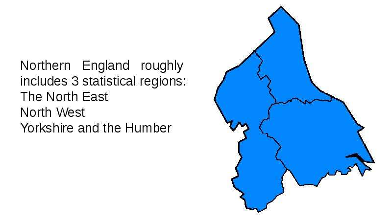
Northern England roughly includes 3 statistical regions: The North East North West Yorkshire and the Humber
Слайд 5
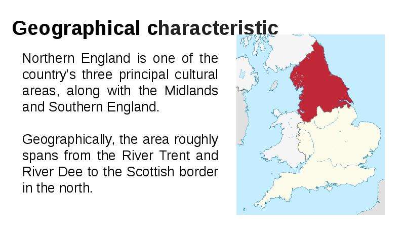
Government Office Regions The north might also be considered to include the three former Government Office Regions of North East England, North West England and Yorkshire and the Humber. This area consists of the ceremonial counties of Cheshire, Cumbria, County Durham, East Riding of Yorkshire, Greater Manchester, Lancashire, Merseyside, Northumberland, North Yorkshire, South Yorkshire, Tyne and Wear and West Yorkshire, plus the unitary authority areas of North Lincolnshire and North East Lincolnshire. The regions also hold the North of England Inward Investment Agency.
Слайд 6
History During antiquity most of the area was part of Brigantia — homeland of the Brigantes and the largest Brythonic kingdom of Great Britain. After the Roman conquest of Britain the city of York became capital of the area, called Britannia Inferior then Britannia Secunda. In Sub-Roman Britain new Brythonic kingdoms of the Hen Ogledd ("Old North") emerged. The Angle settlers created Bernicia and Deira from which came The Kingdom of Northumbria and a Golden Age in cultural.
Слайд 7
Large city The biggest city in the North of England is Liverpool. It is the largest city in the UK with a population of more than 450 thousand people in the city. In 1190 in the place where now stands the modern city, there was a small settlement called Liverpool, which in Russian means "muddy pond". Liverpool was granted city status. And continues to develop actively.
Слайд 8
Программа определяет цель изучения английскому языку как развитие способностей учащихся использовать иностранный язык для общения в диалоге культур современного мира. Поэтому в учебнике много материалов страноведческого и лингвострановедческого характера, текстов, связанных с культурой и историей англоязычных стран. Здесь можно увидеть тесную связь и интеграцию с географией, историей. Во втором семестре начинается блок, посвященный более глубокому изучению Великобритании. Материал учебника представлен как путешествие по самой большой части Великобритании – Англии. Учащиеся знакомятся с основными районами Англии. Предлагаемый в учебнике текст дает краткую характеристику каждому району. К концу изучения данного материала учащиеся должны ясно представлять себе характерные черты этих пяти регионов и уметь кратко описать их.
По моему мнению, страноведческий материал учебника лучше воспринимается учащимися, если снабжен тщательно подобранным наглядным материалом, то есть, картинками, фотографиями, картами. В учебнике к тексту дается только схематичная карта Британских островов с обозначенными разным цветом регионами Англии, далее есть еще одна карта с рисунками, изображающими некоторые наиболее известные достопримечательности. Поэтому я подготовила презентацию к тексту Discover Britain: England. Файлы подобраны в логике, соответствующей материалу страноведческого текста.
После того, как учащиеся прочитали текст, организуется работа по обсуждению его содержания по вопросам с визуальной опорой на файлы презентации. Отвечая на вопросы, учащиеся используют информацию из текста. Некоторые вопросы побуждаю их вспомнить уже изученный ранее материал, описать представленную в презентации картинку или фотографию, а также развивают догадку и способность соотносить информацию учебника с подготовленным учителем видеорядом.
- What is the largest part of the UK? What can you see on the flag of England?
- What is the capital of England? How many people live in London? What river does London stand on? What can you see in the photo?
- What is the saint patron of England? What Russian city has got the same patron? Can you describe the photo/picture?
- What is the symbol of England? Why did the rose become the symbol of England?
- How many regions does England include? Name the regions and show them on the map.
- What historical cities are situated in the Southeast? Which city is Brighton and which is Dover in your opinion? Why do you think so?
- Which county is called “the garden of England”? Why?
- What is the Southwest famous for? What did it use to be famous for?
- What famous monument is situated in the Southwest? Do you anything about Stonehenge?
- What cities are located in the Southwest? What are they famous for?
- What is “land’s end”?
- What famous university city is situated in East Anglia? How do you like the architecture of the city?
- Cambridge is connected with the name of a princess now. Do you know the people in the photo? Who are they?
- What is East Anglia famous for? What famous person was born there?
- Where is the Midlands situated? What cities is this region famous for?
- What famous person was born in the Midlands? What town is popular with tourists?
- What do you know about William Shakespeare?
- What is one of the most famous tragedies of W. Shakespeare? Have you seen these films? Would you like to watch them?
- Theatre was very popular in Shakespeare’s time, wasn’t it?
- How did the theatre in Shakespeare’s time look like?
- What university city is situated in the Midlands?
- What is the North of England famous for? What attracts tourists to the Lake District?
- What did the Romans build in the North of England? How long was it? Why did they build the wall?
Слайды презентации могут быть планом пересказа текста на следующем уроке. Учащиеся могут выбрать понравившиеся или вызвавшие их интерес регионы, чтобы рассказать о них на следующем уроке.
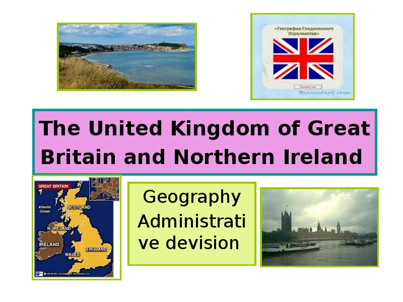
Вы можете изучить и скачать доклад-презентацию на тему The United Kingdom of Great Britain and Northern Ireland. Презентация на заданную тему содержит 7 слайдов. Для просмотра воспользуйтесь проигрывателем, если материал оказался полезным для Вас - поделитесь им с друзьями с помощью социальных кнопок и добавьте наш сайт презентаций в закладки!
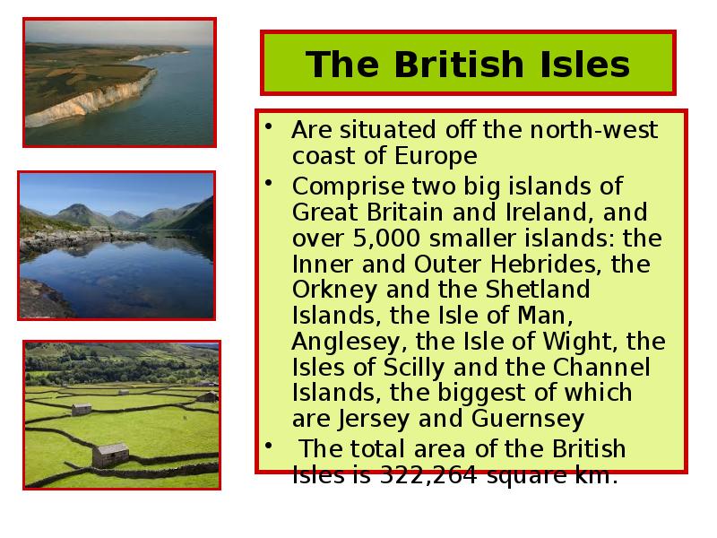


The British Isles Are situated off the north-west coast of Europe Comprise two big islands of Great Britain and Ireland, and over 5,000 smaller islands: the Inner and Outer Hebrides, the Orkney and the Shetland Islands, the Isle of Man, Anglesey, the Isle of Wight, the Isles of Scilly and the Channel Islands, the biggest of which are Jersey and Guernsey The total area of the British Isles is 322,264 square km.
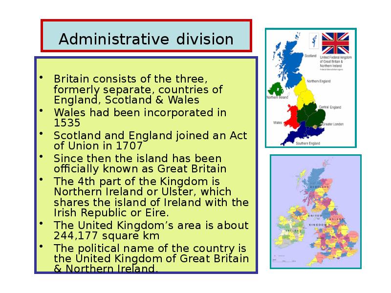
Administrative division Britain consists of the three, formerly separate, countries of England, Scotland & Wales Wales had been incorporated in 1535 Scotland and England joined an Act of Union in 1707 Since then the island has been officially known as Great Britain The 4th part of the Kingdom is Northern Ireland or Ulster, which shares the island of Ireland with the Irish Republic or Eire. The United Kingdom’s area is about 244,177 square km The political name of the country is the United Kingdom of Great Britain & Northern Ireland.
England England covers 50,085 sq miles Is bound by Scotland to the north and Wales to the west 20 miles (32 km) from France across the narrowest part of the English Channel The highest point - Scafell Pike in Cambria, 978m above sea level The Pennines - from Derbyshire to the border with Scotland 250 miles (403km) north (the Pennine Chain or Pennine Hills) The Cambrian Mountains – to the west and the Lake District - the best known of England’s national parks The Midlands – south of the Pennines is the heavily populated central area the industrial heartland since the 19th century The Black Country stretches from north of Birmingham through Staffordshire to Wolverhampton The south-west - the West Country – includes Cornwall, Devon, Dorset and parts of Somerset Dartmoor, Exmoor The eastern part of this region, with Lincolnshire and East Anglia (Norfolk, Suffolk and Cambridgeshire) The Fens - the rich agricultural lands, that extend from Lincoln to Cambridge The North Downs stretch from south of London to Dover The South Downs run across Sussex, parallel to the south coast.
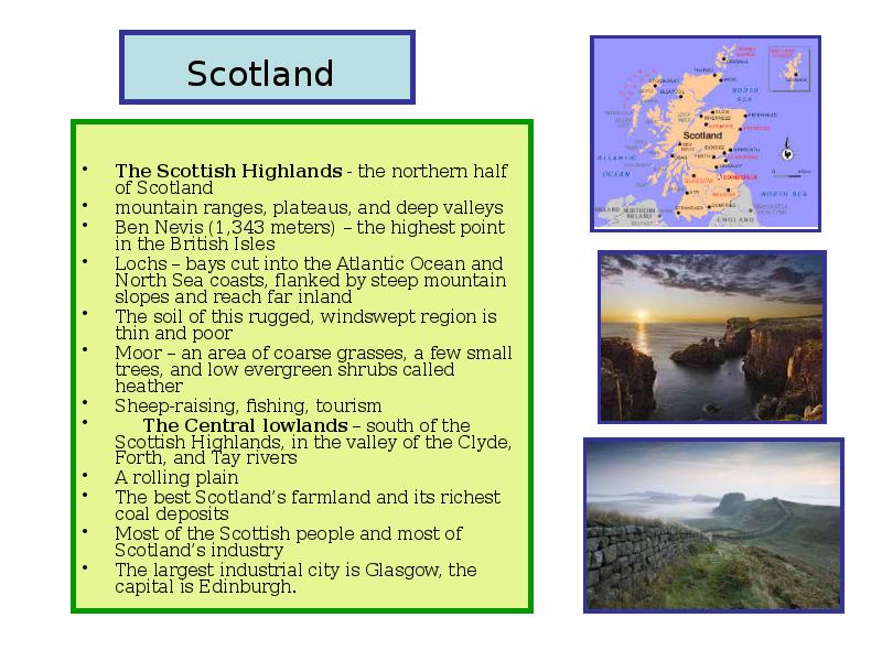
Scotland The Scottish Highlands - the northern half of Scotland mountain ranges, plateaus, and deep valleys Ben Nevis (1,343 meters) – the highest point in the British Isles Lochs – bays cut into the Atlantic Ocean and North Sea coasts, flanked by steep mountain slopes and reach far inland The soil of this rugged, windswept region is thin and poor Moor – an area of coarse grasses, a few small trees, and low evergreen shrubs called heather Sheep-raising, fishing, tourism The Central lowlands – south of the Scottish Highlands, in the valley of the Clyde, Forth, and Tay rivers A rolling plain The best Scotland’s farmland and its richest coal deposits Most of the Scottish people and most of Scotland’s industry The largest industrial city is Glasgow, the capital is Edinburgh.
Wales Wales lies southwest of the Pennines Is separated from the Pennines by a narrow strip of the English lowlands The Cambrian Mountains cover most of the Wales Southern Wales – a plateau deeply cut by river valleys Most of the people live on the narrow coastal plains or in the deep green river valleys Crop farming Grazing sheep Deposits of coal The capital city is a large port of Cardiff
Northern Ireland Low mountains, deep valleys, and fertile lowlands The land is lowest near the centre Rises to its greatest heights near the coasts The chief natural resource is land Crop farming, grazing About a fifth of the people of Northern Ireland live in Belfast, the capital and main industrial centre
Читайте также: